How indoor mapping changes navigation How indoor mapping changes navigation
Skip to main content

Select your location

View of a map in the smartphone screen

How indoor mapping changes navigation

Hardly a day goes by where we don’t use some kind of navigation solution to help us get to where we need to go - Apple/Google Maps, Citymapper, sat-navs, to name but a few. These have not replaced the A-Z, paper maps, or road signs, but they have dramatically enhanced our wayfinding experience. This has made it simultaneously easier and far more efficient to get around - particularly in areas we are unfamiliar with.

Whilst the world of outdoor mapping has been undoubtedly disrupted by these solutions, there remains a giant gap in the end-to-end journey: how do I navigate complex indoor spaces? I know that I can be directed from King’s Cross station to my destination, but how can I ensure that I’m taking the most efficient route from the platform to the best exit for my onward journey?

Low-tech solutions

First let’s look at the existing solutions, and inherent problems. Long standing, low-tech solutions have always managed to do the job, and there are essentially two breeds: signage and people.

Signs are commonplace. We see them everywhere: on the road, in train stations, airports, hospitals, and more than likely, in your own office, too. They give people a general sense of direction and a vague indication of where they currently are. Although some signs can provide clearer directions, with route lines on the ground leading you to your destination, the same problem exists: they can often be vague and poorly placed, leading to confusion.

Scalability is another limiting factor of physical signs. If a building is extended, rearranged, or more points of interest need to be added, increasing the number of signs can become extremely confusing to a user. They also can’t be personalised, as they have to universally appeal to the masses rather than the individual.

For example, an aspiring wizard needs to get to Platform 9 and 3/4. He knows Platform 9 and 3/4 is somewhere in King’s Cross, but without clear direction he may not know exactly where it is. In this example, the wizard in question was only able to find his destination with personalised directions from a station assistant.

Which brings us to verbal directions. We have all found ourselves seeking help at an information point. However, this solution relies on clear directions being given, not to mention the user being able to recall them correctly. Essentially, once you have received the directions, you are on your own. This rings true of signage, and building maps as well. You have to take in the information, remember it, and then follow it. All by yourself. More likely, you will just have to stop again and ask for directions.

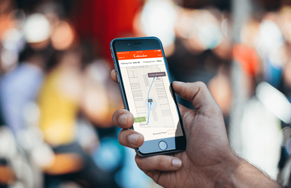
As it stands, lo-fi pointers will help us in our guidance quest, but there’s certainly room for improvement. Enter Indoor Maps.

Signage

Indoor maps - what are they?

Apple has launched a dedicated indoor positioning framework for iOS - called Indoor Survey - which allows users to map out a building using just their iPhone. Surveying a space is simple: all a user needs to do is walk through a building ensuring they cover enough ground and plot points on a map of the building. Nearby radio frequency signal data is combined with the iPhone's sensor data, and then sent up to Apple's servers. This enables indoor positioning across iOS devices.

Indoor maps

Using the Indoor Survey app, we surveyed the Kin + Carta HQ recently, building on its basic functionality to enable pathfinding - the potential of which could be huge. With pathfinding integrated into our proof-of-concept app, a user can see their current location, and then get directions to a point of interest within the office. The app is able to provide you with the shortest path across a multi-level building, drawing out the path across staircases and the floor plan.

Indoor map app

So how can this technology help people get around in the most efficient way? Well, let's apply indoor mapping to real-world, everyday situations in spaces and contexts many of us have, at some point, found confusing and stressful.

"I need to catch my flight on time."

Airport indoor mapping

Diana has checked in at Logan Airport and wants to make sure she can get to her gate on time.

The airline Diana is flying with has a bespoke app, giving her relevant flight information, including which gate to go to. The app is fully integrated with indoor maps. While waiting for her gate to open, she stops off at a few shops to pick up some necessities for a comfortable flight. Whilst there, her gate has been changed, so the app sends a push notification and automatically updates her route, allowing her to avoid the stress of a last-minute gate rush.

"I need to find a particular store in this massive shopping centre."

Accessibility
Accessibility

Shopping centres like Bluewater are enormous. Cavernous, in fact. This is problematic when time is short. Jason, for example, needs to pick up new shoes and pens before picking up his kids from school, so he has limited time.

Physical signs or information points let Jason know the vague direction of each store, but not the fastest way to get there, and the mall map is just confusing. Indoor maps can give him a personalised route to both stores, allowing Jason to get what he needs much more efficiently and still pick the kids up on time.

"I need a wheelchair accessible route to get to my tube platform."

Shopping app

Mike needs to get to Paddington from King’s Cross, and he needs to move around the London Underground stations using wheelchair accessible routes.

When Mike arrives at King’s Cross station, he finds himself overwhelmed by the amount of possible routes. As he is unable to use the stairs and escalators, and needs to get to his platform via lifts. There doesn’t seem to be any staff immediately around to ask. Using Indoor Maps, however, he can easily request directions to his platform, specifying that it needs to be step-free. Taking this into account, he is provided with a map of the shortest route, allowing him to get to the Circle line platform, and on to his destination with greater efficiency and far less stress.

Sounds great, but what does it all mean?

Indoor mapping is brand new, and here at Kin + Carta Create, we are enormously excited to start experimenting with different use cases. The potential is huge, and will certainly be a big stride towards seamless, personalised navigation within physical spaces - end-to-end, indoor and out.

We do not see it as a replacement for physical signs, though: instead, we think of it as an extension to provide an enhanced, personalised experience that signs and verbal directions cannot offer on their own. Working in conjunction with existing lo-fi solutions, we believe that Indoor Mapping can transform the end-to-end experience.

Interested in learning more about indoor mapping?

Get in touch